

Graphical and Numerical Scale
A scale can be displayed on a map either numerically or graphically. The numerical scale corresponds to the expression as a fraction of the ratio of the measured distance on the map and the distance measured on the ground, regardless of the terrain. It is written: 1/25 000 or 1: 25,000, if a unit on the map (1 mm for example) corresponds to 25,000 in the same unit in reality (25,000 mm = 25 m).
The graphical scale represents the same ratio, but as indicated on a ruler drawn on the map and graduated starting from 0 to the values of the actual distance.
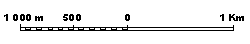
The value of the graphic scale can not be read directly and is estimated by comparison with the map. However, if the map is made smaller, for example through photocopying, the graphical scale remains correct while the numerical scale becomes false.
In an interactive map, the scale, either graphical or numerical, must continuously vary depending on the zoom level.
See: Cartography, Geographic data, GIS project
[French: Echelle]