

english:glossary:spatialresolution
Spatial resolution
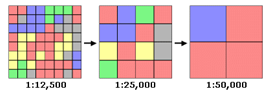
Spatial resolution is the actual size (in m², etc.) of the smallest element represented in a data set. In raster mode, the spatial resolution is the size of the grid cell. In vector mode, polygonal or linear, the spatial resolution is the surface or length of the smallest real entity that can be found in the database. It corresponds to the level of detail in a dataset.
Source: ESRI
See: Scale, Raster (Mode)
english/glossary/spatialresolution.txt · Dernière modification : //20/04/2015 16:36// de taien