

Geographic Information System (GIS)
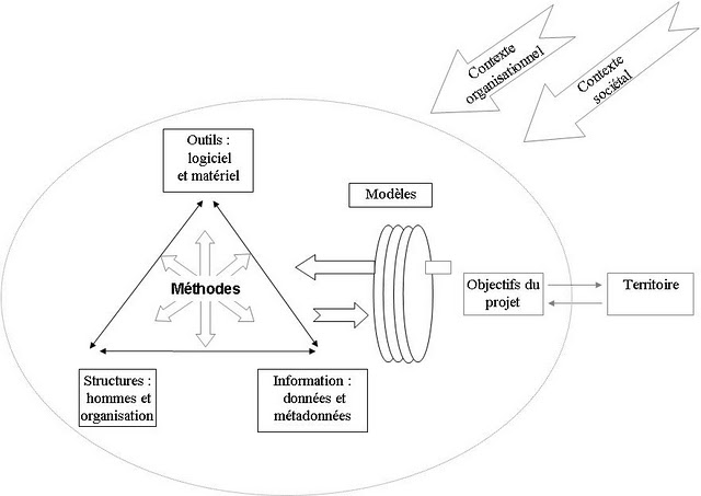
Many definitions of GIS have been proposed over time, which often correspond to the width of the perspective one adopts. A consensus has now emerged on the concept of an information system. A GIS is not a software tool but an information system set up by an organization to describe objects, phenomena and spatial processes that are necessary for action. Like any information system, it combines and articulates data, hardware, software, organizational structures and methods for representing geographic objects required for a project of action and for knowledge of the organization. This can apply to a territory when it comes from a local or regional authority, or a field of activity for a company.
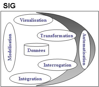
What is the purpose of GIS? Mainly to support the management of geographic data, that is, to organize geographic information, to make an analysis and to communicate. There are usually 6 major functions in a GIS:
- modeling or abstraction of data to develop data models and treatments tailored to the problem
- the integration of data, that is, the constitution of the database itself through collecting new data or acquiring data from different sources
- interrogating the database in the form of queries on spatial characteristics and attribute data
- transforming data to match the needs of the user: changing formats, creating new derivative data, aggregation …
- data visualization in various forms: tables, maps, graphics, three-dimensional views.
- automated processing using a programming language that permits the autonomous performance of complex or repetitive tasks.
See also: Spatial analysis of data, geographical data, visualization, graphic semiology
[French: Système d'Information Géographique (SIG)]